


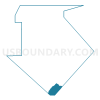
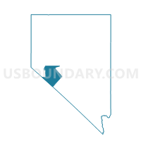
MONTGOMERY PASS PRECINCT 10, Mineral County, Nevada
About
Outline

Summary
| Unique Area Identifier | 615406 |
| Name | MONTGOMERY PASS PRECINCT 10 |
| County | Mineral County |
| State | Nevada |
| Area (square miles) | 72.81 |
| Land Area (square miles) | 72.75 |
| Water Area (square miles) | 0.06 |
| % of Land Area | 99.92 |
| % of Water Area | 0.08 |
| Latitude of the Internal Point | 37.95608330 |
| Longtitude of the Internal Point | -118.39522910 |
Maps

Graphs
Select a template below for downloading or customizing gragh for MONTGOMERY PASS PRECINCT 10, Mineral County, Nevada


Neighbors
Neighoring Voting District (by Name) Neighboring Voting District on the Map
- Voting District 20005, Mono County, CA
- ESMERALDA FISH LAKE VALLEY PRECINCT 3, Esmeralda County, NV
- ESMERALDA LAMBERTUCCI PRECINCT 5, Esmeralda County, NV
- HAWTHORNE RURAL PRECINCT 7, Mineral County, NV
- MINA PRECINCT 9, Mineral County, NV
Top 10 Neighboring County Subdivision (by Population) Neighboring County Subdivision on the Map
- Mammoth Lakes CCD, Mono County, CA (12,117)
- Silver Peak CCD, Esmeralda County, NV (476)
- Mina CCD, Mineral County, NV (233)
Top 10 Neighboring Unified School District (by Population) Neighboring Unified School District on the Map
- Mineral County School District, NV (4,772)
- Eastern Sierra Unified School District, CA (4,258)
- Esmeralda County School District, NV (783)
Top 10 Neighboring State Legislative District Lower Chamber (by Population) Neighboring State Legislative District Lower Chamber on the Map
Top 10 Neighboring State Legislative District Upper Chamber (by Population) Neighboring State Legislative District Upper Chamber on the Map
Top 10 Neighboring 111th Congressional District (by Population) Neighboring 111th Congressional District on the Map
Top 10 Neighboring Census Tract (by Population) Neighboring Census Tract on the Map
- Census Tract 1.01, Mono County, CA (3,463)
- Census Tract 9708, Mineral County, NV (1,337)
- Census Tract 9501, Esmeralda County, NV (783)